


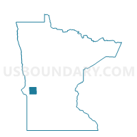
Scott Twp. Voting District, Stevens County, Minnesota
About
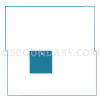
Outline

Summary
| Unique Area Identifier | 604567 |
| Name | Scott Twp. Voting District |
| County | Stevens County |
| State | Minnesota |
| Area (square miles) | 35.52 |
| Land Area (square miles) | 33.65 |
| Water Area (square miles) | 1.87 |
| % of Land Area | 94.74 |
| % of Water Area | 5.26 |
| Latitude of the Internal Point | 45.53523790 |
| Longtitude of the Internal Point | -96.04561260 |
Maps

Graphs
Select a template below for downloading or customizing gragh for Scott Twp. Voting District, Stevens County, Minnesota


Neighbors
Neighoring Voting District (by Name) Neighboring Voting District on the Map
- Alberta Voting District, Stevens County, MN
- Baker Twp. Voting District, Stevens County, MN
- Darnen Twp. Voting District, Stevens County, MN
- Horton Twp. Voting District, Stevens County, MN
- Morris Twp. Voting District, Stevens County, MN
- Pepperton Twp. Voting District, Stevens County, MN
- Stevens Twp. Voting District, Stevens County, MN
- Synnes Twp. Voting District, Stevens County, MN
Top 10 Neighboring County Subdivision (by Population) Neighboring County Subdivision on the Map
- Morris township, Stevens County, MN (396)
- Darnen township, Stevens County, MN (292)
- Horton township, Stevens County, MN (174)
- Scott township, Stevens County, MN (144)
- Pepperton township, Stevens County, MN (134)
- Synnes township, Stevens County, MN (118)
- Baker township, Stevens County, MN (114)
- Alberta city, Stevens County, MN (103)
- Stevens township, Stevens County, MN (77)